Mekong-Ganges Physical connection -- Geographical evidences from Valmiki Ramayana
K.Gopalakrishnan, Director-SG (retired), Geological Survey of India (October 2018)
Introduction
If one looks at the world map, one will find that Ganga (Ganges) river, India and Mekong river, Indonesia were wide apart physically and separated by many other major rivers of SE Asia like Irrawaddy, Salween and Mekong and intervened by many mountain ranges. Under those circumstances, the topic of this article will look absurd to many readers. At the same time, it may tempt some to read trough this article. That is the aim of this article. When the reader comes to the end of this presentation, he will find the truth and genuine nature of the statements of the heading. The connection between Mekong and Ganges will be traced through TIME (from 21 Century to Treta Yuga – around 2 Million years) andfinally through SPACE (Physical connection through Geography) during Ramayana period.
Fig. 1a
Fig. 1b.
![]() Fig. 1c.
Fig. 1c.TIN ROUTE – BRONZE AGE (3000 BC to 1200 BC) CONNECTION.
Recently a communication I received from Dr.S.Kalyanaraman, the eminent Indologist and an renowned expert on Saraswati Valley Civilisation showed what was described as an Ancient Tin Route from Hanoi, Vietnam to Haifa, Israel, a reverine cum maritime route, initially along reverine passage through the SE Asian rivers of Irrawaddy, Salween and Mekong to the ocean then a maritime route passing through Malacca Straights to the delta of Ganges – Brahmaputra rivers. Then again a reverine route was shown via Karatoya along Ganges and Yamuna to Rakhigarhi, Hariyana. Rakhigarhi was considered to be the capital of Saraswati valley civilisation which showed evidences of knowledge of Bronze metallurgy. Further riverine passage through the ancient Saraswati river to Arabian sea. From there the Tin route takes again a maritime rout via Gulf of Arabia and later land route through ancient Mesopotamia and Babylon to Haifa.
Fib-2 – Ancient Hanoi – Haifa Tin Route
It is significant that this link between Mekong and Ganges was mentioned for the period of Bronze age - 5,000 – 3,200 years before present. The mention of suggested linkage of Mekong and Ganges as a part of ancient Tin Route brought to my memory a few things about the known linkages of these two rivers known from different aspects during various periods of history. I will share some of these known facts, which will be a good prelude to my main article on the physical link between them.
Those readers who want to avoid these preliminaries can go directly to sub-heading - GEOGRAPHICAL AND GEOLOGICAL EVIDENCES FROM VALMIKI RAMAYANA.
MEKONG–GANGA COOPERATION – 21ST CENTURY CONNECTION
From Wikipedia, the free encyclopedia
The Mekong–Ganga Cooperation (MGC) was established on November 10, 2000, at Vientiane, Laos at the First MGC Ministerial Meeting. It comprises six member countries, namely India (Look-East connectivity projects), Thailand, Myanmar, Cambodia, Laos and Vietnam. The four areas of cooperation are tourism, culture, education, and transportation.] The organization takes its name from the Ganga and the Mekong, two large rivers in the region. It is significant that the MGC was established during the previous NDA Government in India. The selection of the names of these two major rivers from for this six nation co-operation is of interest, instead of using a name generated from the initial letters of the names the member countries. THUS WE SEE A CONNECTION BETWEEN MEKONG AND GANGA ON GOVERNMENT / POLITICAL LEVEL DURING THE BEGINNING OF 21ST CENTURY.
THE GREATER INDIA CONCEPT – 15TH CENTUY CONNECTION
Fig-3 - Map of Greater India – Wikipedia.
Next in consideration is the concept of “Greater India” and the term “Greater India”. The term Greater India is most commonly used to encompass the historical and geographic extent of all political entities of the Indian subcontinent, and the regions which are culturally linked to India or received significant Indian cultural influence. These countries have to varying degrees been transformed by the acceptance and induction of cultural and institutional elements of India. Since around 500 BCE, Asia's expanding land and maritime trade had resulted in prolonged socio-economic and cultural stimulation and diffusion of Hindu and Buddhist beliefs into the region's cosmology, in particular in Southeast Asia and Sri Lanka. In Central Asia, transmission of ideas were predominantly of a religious nature. By the early centuries of the common era most of the principalities of Southeast Asia had effectively absorbed defining aspects of Hindu culture, religion and administration. The notion of divine god-kingship was introduced by the concept of Harihara, Sanskrit and other Indian epigraphic systems were declared official, like those of the south Indian Pallava dynasty and Chalukya dynasty. These Indianized Kingdoms, a term coined by George Cœdès in his work Histoire ancienne des états hindouisés d'Extrême-Orient (1944), were characterized by surprising resilience, political integrity and administrative stability. THIS CONNECTION BETWEEN INDIA AND THE FAR EAST DATES BACK TO 15TH CENTURY.https://en.wikipedia.org/wiki/Greater_IndiaThis Greater India was achieved NOT by invasion, conquest, occupation, subjugation, coercion and conversion, but SOLELY through interactions between societies through Culture and Commerce. The people of the ancient SE Asia consisting of countries like Burma, Malasia, Indonesia, Thailand, Laos, Siam (Cambodia) and Vietnam had differences in their race, language, history, food and dress habits and their individual arts and culture. But the ‘Way of Life’ of the ancient Indians (the Sanatana Dharma), their knowledge in various spheres, the superior art forms of sculpture, painting, dance and dramas, their religious beliefs and faiths, their superior type of administration etc had made great impact on the SE Asian societies during the early periods and was an inspiration to follow. They simply imbibed them into their own walks of life forming a culturally well knit society merging with the ancient India, thus forming the “Greater India”, but still possessing their individual status. It should be remembered that even the present-day Republic of India, is a single country now governed by a federal structure. But before the invasion and occupation of Bharat by the Moguls and Britishers, it was made up of various States of different races, languages, customs and habits and individual cultures of their own, and ruled by different kings, but were unified by major cultural absorptions and a common way of life and Governance (by Sanatana Dharma). MAPS OF CLAUDIUS PTOLEMY (100 TO 170 CE)- 2ND CE CONNECTION The next link between Ganges and Mekong comes from ancient maps of the world and of India by Ptolemy, one of earliest Greek Astronemor, Mathematician, Geographer and Cartographer, whose maps of ancient India depicted ‘Intra-Gangem’ and ‘Extra-Gangem (meaning this side and that side of Ganges).
Fig.4. Ptolemy’s Map of Africa and Asia
See the below maps – Figures – 5a,b and c.
Fig-5a. -SE.ASIA, India, Burma,Indonesia,Malaysia -Van Den Keere, Cluver antique map 1661, showing Intra and Extra Gangem
Fig. 5b - 1720 Weigel Map of India and Southeast Asia, showing Intra and Extra Gangem based on Ptolemy’s maps.
Fig. 5c -Mercator Map 1595, showing India Extra-Gangem on the right and India Intra-Gangem on the left. See Sinus Magnem – South China Sea on right.
Thus it can be seen from the maps of Ptolemy and later maps based on them showed that the Far East (Indochina) was linked and formed a part of Ancient India from about 2000 years ago, confirming the Greater India concept (referred above) to those earlier times also.
BUT IT IS SIGNIFICANT THAT ALL THESE MAPS GAVE PROMINENCE TO THE TERM GANGEM / GANGA RIVER, WHILE REFERING TO GREATER INDIA THAT INCLUDED INDOCHINA. Some people consider that the name Mekong is derived from the pro-name of MA- GANGA (Mother Ganga). HOWEVER, THESE MAPS ALSO DO NOT CONFIRM ANY ACUAL PHYSICAL LINKS BETWEEN MEKONG AND GANGES RIVERS.
GEOGRAPHICAL AND GEOLOGICAL EVIDENCES FROM VALMIKI RAMAYANA – TRETA YUGA (2 Ma) CONNECTION
In my recent article on “ORIGIN OF GANGES AND TECTONICS OF HIMALAYAS –EMBEDDED GEOLOGICAL TRUTHS IN VALMIKI RAMAYANA”, the following points are brought out.
1. In the story related to bringing Ganga to the earth by king Bhageerata also, Valmiki described the complexly folded locks of hair on the head of Lord Shiva initially acted as a retardant to the mighty force of Ganga falling from the sky and holding and locking it up in his hair – jatamandala mohinta (1-43-9).
Fig.6
2. Valmiki later described the formation of ice on the peak of Mt. Kailash with the waters of Ganga. On melting later, the water was let out into the Manasarovar Lake at the foot of the great mountain – bhindu saraha prati gangaam visasarja(1-43-11).
3. After the fall on to the earth, Ganges was split into seven branches of flows – sapta strotamsi janjhirey (1-43-12). The seven branches however, flowed in THREE DISTINCT DIRECTIONS (3 Paths /THRIPATHAGAI).
4. Valmiki gives special significance and reference to the name of ‘Tripathaagai’ to Ganga at many places in Bala kandom of Ramayana.
5. The below maps (6a and b) show the Tripathaagai nature of Original River Ganga originating from Mt. Kailash / Manasarovar region flowing east as Yarlong / Tsangpo, west as Indus / Sindhu and south as Ganga / Ganges.
Fig.7a.
Fig. 7b.
6. The original Akaash Ganga flowed eastwards as ‘Hlaadinee, Pavanee and Nalinee rivers, while the flow westwards was covered by Suchakshu, Seetha and Sindu. The seventh branch Ganga flowed southwards following Bhageeratha. (1-43-13, 14 & 15).
7. THE ABOVE DESCRIPTION CLEARLY POINTS OUT THAT DURING ANCIENT TIMES, ALL THE THREE HOLY MAJOR RIVER SYSTEMS ORIGINATING FROM MT. KAILASH / MANASAOVAR LAKE REGION ARE CONSIDERED AS ONE GANGA RIVERTHAT FLOWED ALONG THREE PATHS.
8. THE DESCRIPTION ALSO COINCIDEDS WITH THE ACTUAL FLOWING OF MAJOR RIVERS FROM THE MT. KAILASH; RIVER TSANGPO /BRAHMAPUTRA AND ITS TRIBUTERIES FLOW EASTWARDS, WHILE SINDHU RIVER AND ITS TRIBUTERIES FLOW WESTWARDS AND GANGES AND ITS TRIBUTERIES FLOW SOUTHWARDS. THESE ARE THE THREE PATHWAYS (TRIPATHAGAIS) OF GANGES DESCRIBED BY VALMIKI IN RAMAYANA.
9. It is astonishing that the tripataagai nature of the three major river systems of India, a very important and interesting GEOGRAPHICAL TRUTH, was known to our ancients, which would have been possible ONLY FROM AN AERIAL VIEW OF THE ENTIRE REGION.
10. For easy reference and understanding, let us call these rivers in three directions as Eastern Ganga, Western Ganga and Main Ganga.
CONNNECTION OF GANGA ANG KAILASH MOUNTAINS – Fig.8.
Fig.8a.
Compare the above topographic expression of Mt. Kailash wit the Idol of Lord Shiva lingan with Aavudaiyar around it in the figure below.
Fig.8b.
11. Kailas Range, Chinese (Pinyin) Gangdisi Shan or (Wade-Giles romanization) Kang-ti-ssu Shan, Tibetan Gang Tise, also called Gangdisê Range, one of the highest and most rugged parts of the Himalayas, located in the southwestern part of the TibetAutonomous Region, southwestern China. The range has a roughly northwest-southeast axis and lies to the north of a trough drained in the west by the Langqên (Xiangquan) River—which is known as the Sutlej River in India—and in the east by the Damqog (Maquan) River, headwater of the Brahmaputra River (in China called the Yarlung [Yaluzangbu] River). In the middle of this depression lies Lake Mapam, reputed to be the highest freshwater lake in the world, 14,950 feet (4,557 metres) above sea level. To the north of this lake lies Mount Kailas, which reaches an elevation of 22,028 feet (6,714 metres); it is known as Gang Tise to the Tibetans and is the highest peak in the range. (https://www.britannica.com/place/Kailas-Range). 12. Gangdise - Nyenchen Tanglha Mountains
Located at the middle part of Qinghai-Tibet Plateau, Gangdise - Nyenchen Tanglha Mountains is a huge mountain chain extending from east to west. It is the boundary of South Tibet and East Tibet, and also the boundary of exterior and interior rivers. The mountains are 1500 km long and 80 km wide with an average altitude from 5000 to 6000 m. There are 25 peaks with altitude over 6000 m. The main peak of Gangdise mountains – Mount Kailash is 6656 m above the sea leavel. And Mount Nyainqentanglha of the Nyenchen Tanglha Mountains is 7717 m above the sea level. Mount Kailash is the famous pilgrimage site of Hinduism, Buddhism and Jainism.
13. PLEASE NOTE THAT THE NAMES ASOCIATED WITH KAILASH RANGES AS WELL AS WITH MT. KAILAS IN CHINESE AND TIBETAN LANGUAGES ALSO HAVE PREFIXES OF GANGDESI, GANGTISE, GANGDESE ETC. ONE OF THE GEOLOGICAL FORMATIONS IN LHAASA TERRANE IS KNOWN AS “GANGDISE BATHOLITH”. All these are POINTING OUT THEIRPROBABLE CONNECTION TO RIVERGANGA.
14. Let us now turn to the Eastern Ganga formed of three branches. At the present day, one can see only one major river flowing eastwards from Manasarovar as Tsangpo / Yarlung / Dsangbo which on entering India is known as Brahmaputra. BUT AS PER VALMIKI RAMAYANA, EASTERN GANGA HAD THREE BRANCHES.
15. Our recent analysis of rivers from Tibetan Plateau shows that actually the three rivers – Tsangpo, Salween and Mekong joined and flowed as one during ancient times, but later got separated as three different rivers due to later tectonic activities. AS SUCH, WE CAN CONCLUDE THAT THESE THREE RIVERS ACTUALLY FORMED THE EASTERN GANGA. Our ancestors realised these facts and actually named one of these rivers as MAA GANGA WHICH WAS LATER CHANGED TO MEKONG.
16. We will demonstrate this activity through a number of maps.
17. The below map (Fig.9) shows the present-day major river basins of SE Asia.
Fig.9
GLACIERS AND GLACIATION IN TIBET
About two million years ago during the Pleistocene times, the earth entered a major ice age. Polar ice caps grew, reaching as far south as the northern US and covering the entire Tibetan Plateau and Himalayas. Ice sheets advanced and retreated four times, most recently retreating only 10,000 years ago - a few minutes in geologic time. Only the Antarctic have more ice than the glacial highlands of the Tibetan Plateau, earning it (the latter) the nickname "the third pole."
It is significant that this formation of huge Glaciation event covering Tibet during Pleistocene (around 2 Ma) coincides with Ramayana Times of TRETA YUGA (2Ma) as well as the analogy / allegory of Akash Ganga getting locked up in the matted and knotted hairof Lord Shiv and formed the great SWETA (WHITE) MOUNGTAINS (Kailas Ranges) as described in Valmiki Ramayana.
Fig.10a.
Note the present-day physical expression of Tibetan Plateau (in the centre of the map in pale pink colour, studded with white coloured ice capped ridges in different directions and small blue coloured Glacial Lakes. Mount Kailas and Manasarovar Lakes are seen at the left bottom of map bordering Nepal and just north of Gurla Mandata eak (∆7728).
NOW IMAGINE THAT YOU ARE LOOKING FROM ABOVE (SPACE) AT THE HEAD COVERED WITH MATTED AND KNOTTED HAIR OF LORD SHIVA AND HOLDING THE WATERS OF AAKASH GANGA WHICH HAD FORMED ICE AND SNOW ON THE RIDES OF THE MATTED HAIR AND THE IN- BETWEEN DEPRESSIONS HOLDING THE HOLY WATER OF GANGA. Now compare the above topo- map and your imagination above (which is actually the description in Valmiki Ramayana) and how they fit nicely. What we are seeing is that Lord Shiva is looking towards south with his long MANE of Matted hair flowing towards north. See also Kailas Ranges and Mt. Kailash at the southern edge of Tibet with Manasarovar at its base.
10b.
The effect of these ice sheets on topography was dramatic. Mountain tops were eroded to form jagged peaks and ridges while valleys were filled with glacial sediment. Strong winds winnowed out the fine silt (called loess), depositing thick layers of it across the entire upper Yellow River basin (hence its name), and leaving behind coarser sand and gravel which today chokes the river beds. As a result, the headwaters of all of the major rivers on the Tibetan Plateau are braided streams flowing over glacial gravels in broad valleys, characterized by constant moderate gradients and few significant rapids. By the time they begin to flow off the Plateau, the rivers have gained the volume necessary to erode these gravels and renew the process of cutting deep, narrow canyons in underlying bedrock. Where they flow over hard layers and giant boulders, there are huge rapids such as Tibetan Terminator and Dragon's Teeth on the Mekong, Leaping Tiger Rapids on the Salween, Tiger Leap Gorge on the Yangtze, and waterfalls such as Rainbow and Hidden Falls in the Great Bend of the Yarlung Tsangpo.
ZDROJ:http://www.shangri-la-river-expeditions.com/wchinageo/wchinageo.html
The below map (Fig.11) shows the braided / dendritic drainage pattern of SE Tibet during post- Pleistocene glaciation and prior to the uplift. Note that the three rivers, Tsangpo, Salween and Mekong join and form a single river (Red River), confirming the Eastern Ganga with three branches as depicted in Valmiki Ramayana. The other easterly tributaries like Yangtse, Yalong, Dadu etc shown in this map were probably not very prominent during Ramayana times.
Fig.11 - Geologie a geovědy v Číně, 2008TECTONICS OF TIBET DUTING PRE TO SYN PLEISTOCENE GLACIATION
In the Figure-12 At 40 Ma ago during the initial collision of Indian block along the western margins, while the central and eastern Tibet were subjected to subduction of Tethys below Asia / Tibet. The direction of movement of Indian plate was NE.
![]() Fig.12.
Fig.12.
![]() Fig.13
Fig.13The above figure-13 shows the movement of India- Sri Lanka plate moving NE to collide with Asia during different geological periods from 71 Ma ago to present day. The anti-clockwise turning of the India – Sri Lanka block during collision from Cretaceous to present-day, which had resulted in the formation of Eastern Himalayan Syntaxis around Namche Bharwa in Siang district, Arunachal Pradesh.
IN THE BELOW MAP (Fig.14), NOTE THE BLACK ARROWS AROUND INDIA INDICATIONG THE MOEMENT DIRECTION OF INDIAN PLATE DURING COLLISION AND THE RESPONSE OF EURASIAN PLATE SWERVING AROUND THE EASTERN HIMALAYAN SYNTAXIS RESULTING IN BENDING OF OROGENIC BELTS AS WELL AS THE PRE-EXISTING DRAINAGES OF TIBETAN PLATEAU.
![]() Fig-14.
Fig-14. This major and important tectonic activity had resulted in the complete change of the drainage direction of all the rivers flowing eastwards from the Tibetian Plateau towards south.
This activity had also brought in many other upliftswithin the Tibetan plateau itself, at places accompanied with distinct dextral strike-slip faulting, which had resulted in separation of the rivers Mekong, Salween and Tsangpo from the Red river.
In particular, this activity resulted in the acute bend and turning of Tsangpo river course from eastwards to westwards on the southern side of Himalayas in the plains of Assam as Brahmaputra river. THIS FACT CLEARLY DEMONSTRATES THAT THE CONFLUENCE OF PALEO-TSANGPO WITH SALWEEN EXISTED AT OR AROUND SIANG SYNTAXIAL BEND. (See the above map showing position of Collision during 40Ma ago).
In the map below (Fig.15), please note that while the NE motion of crust occurred at around 10 Ma. The clock-wise rotation of the southern and SE parts of Tibet as a response to the anti-clockwise rotation of the Indian Plate, is shown by black arrows. Also see that the NW-SE trending Red River Fault (along the right botoom of map), passing through the initial drainages of Salween, Mekong and Yangtse rivers. The dextral (right lateral) strike-slip faulting along this line during recent times had separated the drainages of the three river systems. According to geoscientists from the Seismological Bureau of Yunnan, MIT and Cal Tech, theRed River Fault has about three miles of right-lateral displacement.The displacement is quite recent - certainly in the last two to three million years. It is most likely to be Post- 2 Ma Pleistoceneglaciations and formation of Eastern Ganga with three branches.
![]() Fig. 15 - Geologie a geovědy v Číně, 2008
Fig. 15 - Geologie a geovědy v Číně, 2008 For hundreds of miles before its confluence with the Yangbi, the Mekong is sandwiched in between the Salween (Nu) River on the west and the Yangtze (Jinsha) River on the east. In western Yunnan, the three rivers diverge - the Yangtze turns north, then east, the Mekong turns southeast, then south, and the Salween continues to the south (Fig.16).![]() Fig.16 - Geologie a geovědy v Číně, 2008
Fig.16 - Geologie a geovědy v Číně, 2008 NOTE IN THE ABOVE MAP (Fig.14), SALWEEN AND MEKONG RIVERS SEPARATE AS INDEPENDANT RIVERS TOWARDS WEST FROM RED RIVER, WHILE YANGTSE RIVER (AS WELL AS THE PALEO-UPPER REACHES OF RED RIVER SEPARATE AND FLOW EAST, MAKING THE RED RIVER TO BE A VERY SMALL RIVER FROM ITS ORIGINAL SIZE FLOWING SE.
Thus, it can be seen that strain resulting from the collision of India with Asia has caused fundamental changes to Asian drainage patterns. It can be seen that the 4 major rivers, Yangtse, Mekong, Salween and Tsangpo which originally formed as branches of a dendritic drainage of RED river after the 2Ma Pleistocene Glaciation, got separated later due the above tectonic activities.
Valmiki Ramayana had described the Pleistocene Glaciation affecting the entire Tibet and in particular the Kailas Mountin ranges and forming ice and snow clad Sweta Mountains(Kailash Ranges) correctly at the specific geographical location from which the melt waters produced the flow of the Tripatagai Ganga river
The Ramayana period was supposed to be in Treta Yuga , about 2 Ma ago, wherein the three branch rivers of Eastern Ganga were described. It was shown from many maps described above that actually the Eastern Ganga was formed of both Ganga (Tsangpo) and Mekong, besides Salween, during Ramayana times and later got separated.
THUS VALMIKI RAMAYANA HAD DEMONSTRATED THE GEOGRAPHICAL (PHYSICAL) AND GEOLOGICAL (TECTONIC) TRUTH OF A LINK / CONNECTION BETWEEN ANCIENT GANGA AND MEKONG DURING PERIOD FROM ABOUT TWO MILLION YEARS AGO.
The geological connection through metallogeny between these two areas will be presented in a later article.


 Sign 4 Variants


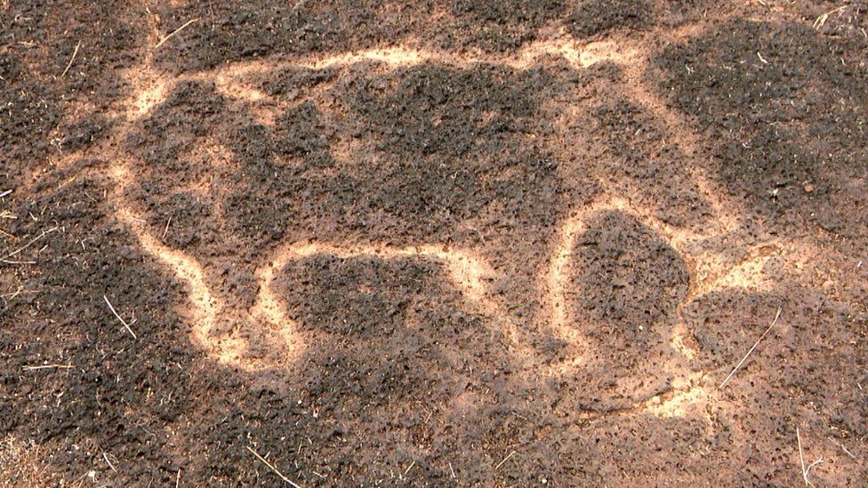
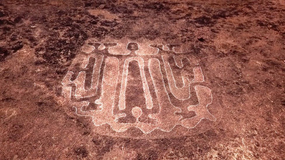
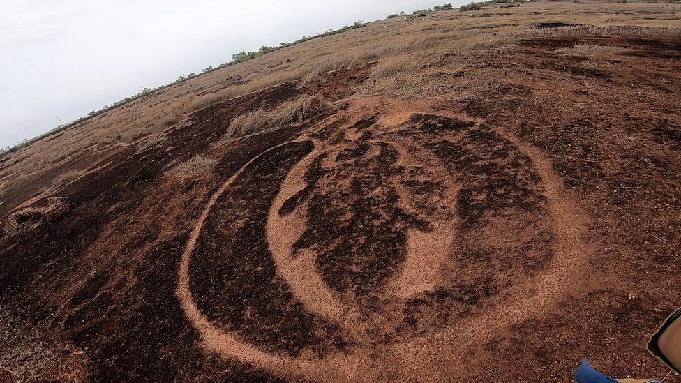
 The discovery of rock carvings believed to be tens of thousands of years old in India's western state of Maharashtra has greatly excited archaeologists who believe they hold clues to a previously unknown civilisation, BBC Marathi's Mayuresh Konnur reports.
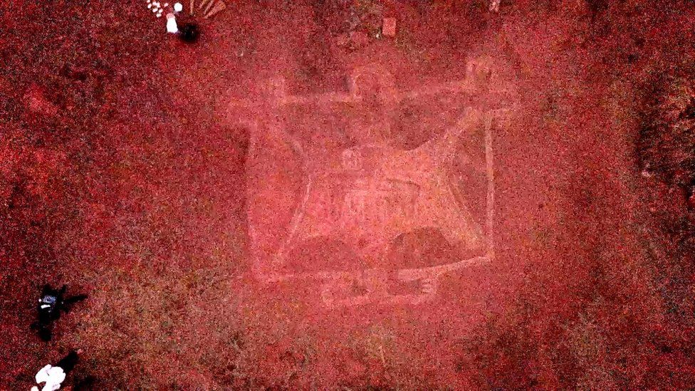


 9.074.02 The supporter of heaven, the prop (of the earth), the Soma-juice who, widely spreading, filling (the vessels), flows in all directions-- may he unite the two great worlds by his own strength; he has upheld them combined; (may he) the sage (bestow) food upon (his worshippers). [The prop of the earth: cf. RV. 9.089.06; may he unite: yaks.at = sam.yojayatu; a_vr.ta = by its own unaided strength].
 9.089.06 The prop of heaven, the support of earth-- all beings (are) in his hands; may (Soma) the fountain (of desires) be possessed of horses for you (his) adorer; the filament of the sweet-flavoured (Soma) is purified for (the sake of winning) strength.

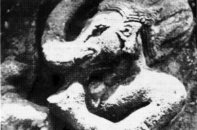 He also carries a rattle or a bone (broken tusk? to signify his role as a scribe.)