Mirror: http://tinyurl.com/jjzq6fs
![]() The cosmic dance of Plate tectonics; the Indian plate is moving northwards 6 cm per year and lifting up the Eurasian plate creating the Himalayan ranges from Hanoi to Teheran growing 1 cm every year.
The cosmic dance of Plate tectonics; the Indian plate is moving northwards 6 cm per year and lifting up the Eurasian plate creating the Himalayan ranges from Hanoi to Teheran growing 1 cm every year.![]() Uttarakhand
Uttarakhand![]()
![]()
![]()
![]()
![]()
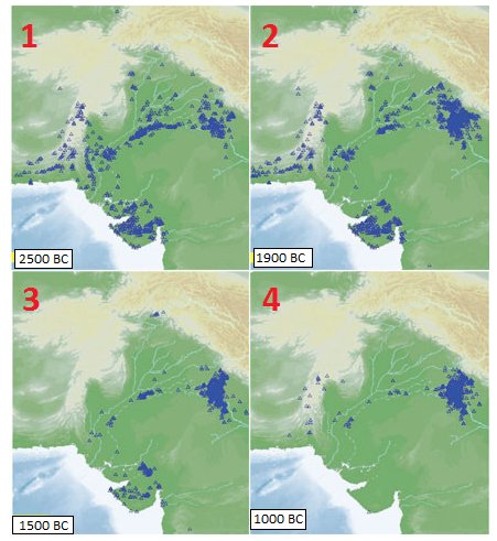
![]() "Researchers at the Institute of Mathematical Sciences (IMS), Chennai, combined data from archaeology, radiocarbon dating, and river flows to study how settlements around the Indus Valley region had evolved from around 7000 BC till 1000 BC. Their analysis of 1,874 Indus region settlements has shown that the Indus urbanisation had three epicentres — Mehrgarh in present-day Baluchistan, Gujarat, and sites along an ancient river called the Ghaggar-Hakra in Haryana and Punjab.The findings, published in Current Science, a journal of the Indian Academy of Sciences, dispute suggestions by international researchers that farming and urbanisation in the region was driven by a “wave of advance” moving eastward,,.We’re looking at large-scale patterns of how the Indus civilisation changed over time,” said Ronojoy Adhikari, a theoretical physicist at the IMS, who led a team that analysed geographic movements of Indus region settlements over hundreds of years...The study shows a “catastrophic reduction” in the number of sites in the Ghaggar-Hakra region around 1900 BC. Over time, the Indus sites moved upstream, but they were smaller in size and appear to show a breakdown in large urbanisation. But the decline around Mehrgarh and Gujarat occurred at a much slower pace. Gujarat remained relatively unscathed during the Ghaggar-Hakra collapse" http://mitchtestone.blogspot.in/2010/04/indus-valley-east-theory-challenged.htmlDrishadvati-Ghaggar-Hakra River archaeological evidence points to ca. 2500 BCE as the start date for the desiccation of Vedic River Sarasvati
"Researchers at the Institute of Mathematical Sciences (IMS), Chennai, combined data from archaeology, radiocarbon dating, and river flows to study how settlements around the Indus Valley region had evolved from around 7000 BC till 1000 BC. Their analysis of 1,874 Indus region settlements has shown that the Indus urbanisation had three epicentres — Mehrgarh in present-day Baluchistan, Gujarat, and sites along an ancient river called the Ghaggar-Hakra in Haryana and Punjab.The findings, published in Current Science, a journal of the Indian Academy of Sciences, dispute suggestions by international researchers that farming and urbanisation in the region was driven by a “wave of advance” moving eastward,,.We’re looking at large-scale patterns of how the Indus civilisation changed over time,” said Ronojoy Adhikari, a theoretical physicist at the IMS, who led a team that analysed geographic movements of Indus region settlements over hundreds of years...The study shows a “catastrophic reduction” in the number of sites in the Ghaggar-Hakra region around 1900 BC. Over time, the Indus sites moved upstream, but they were smaller in size and appear to show a breakdown in large urbanisation. But the decline around Mehrgarh and Gujarat occurred at a much slower pace. Gujarat remained relatively unscathed during the Ghaggar-Hakra collapse" http://mitchtestone.blogspot.in/2010/04/indus-valley-east-theory-challenged.htmlDrishadvati-Ghaggar-Hakra River archaeological evidence points to ca. 2500 BCE as the start date for the desiccation of Vedic River Sarasvati
This note provides a framework for reconstructing the navigable channel on Drishadvati-Sarasvati River system for seafaring merchants from Rakhigarhi.![]()

 Uttarakhand
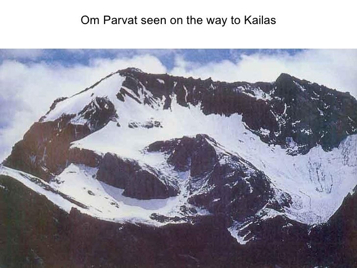


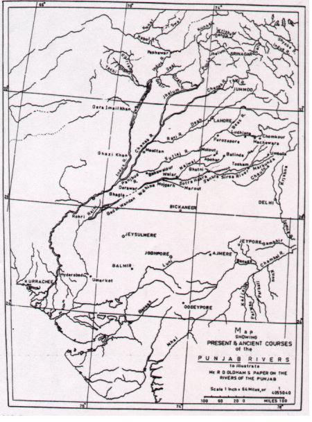
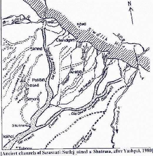
Present and ancient courses of the Punjab rivers (After R.D. Oldham, 1887, On probable changes in the geography of the Punjab and its rivers. An historico-geographical study. Journal of the Asiatic Society of Bengal, 55: 322-343).


Map showing the bird's foot palaeo-delta complex representing the mouths of three rivers identified as Shatadru (Hakra), Saraswati and Drishadvati (after ali et al.; after Fig. 3 in: Roy, AB & SR Jakhar, Late quaternary drainage disorganization, and migrtion and extinction of the Vedic Saraswati in Current Science, Vol. 81, No. 9, 10 November 2001, pp. 1188-1195 Source: http://tejas.serc.iisc.ernet.in/~currsci/nov102001/1188.pdf http://bharatkalyan97.blogspot.in/2013/08/dholavira-gateway-to-meluhha-gateway-to.html

![]()
![]() Rakhigarhi was on the banks of River Drishadvati, a tributary of River Sarasvati navigable through and beyond Dwaraka through Persian Gulf into Ancient Near East. (Map after JM Kenoyer harappa.com).
Rakhigarhi was on the banks of River Drishadvati, a tributary of River Sarasvati navigable through and beyond Dwaraka through Persian Gulf into Ancient Near East. (Map after JM Kenoyer harappa.com).![]()
![]()
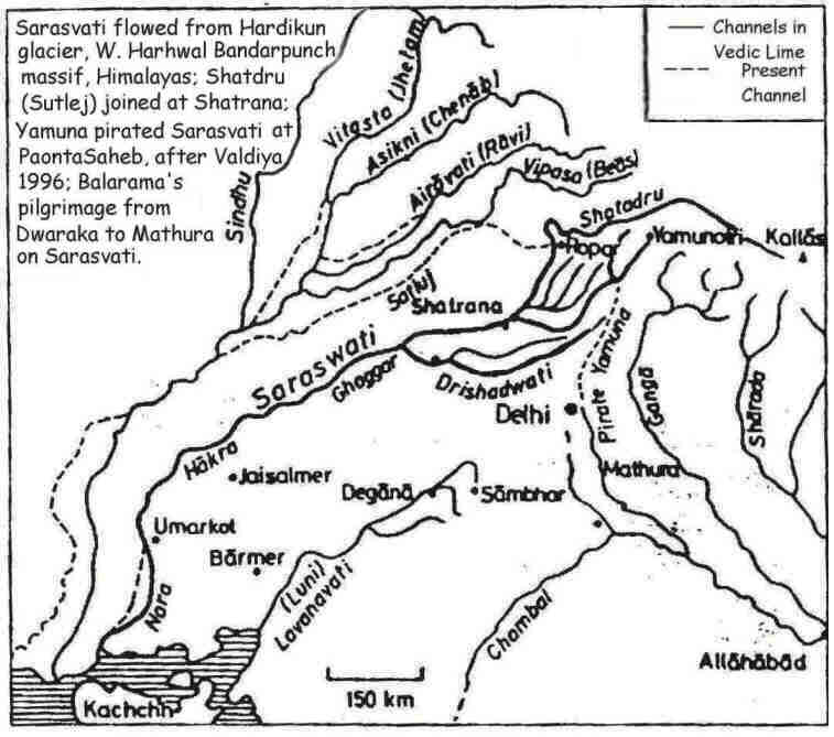
![]() Drishadvati was a tributary of River Sarasvati (Dotted lines indicate the present-day river flows)
Drishadvati was a tributary of River Sarasvati (Dotted lines indicate the present-day river flows)![1056.jpg (17594 bytes)]()
![]()
![]()
![]()
![]()
![]()
![]()


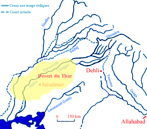 Drishadvati was a tributary of River Sarasvati (Dotted lines indicate the present-day river flows)


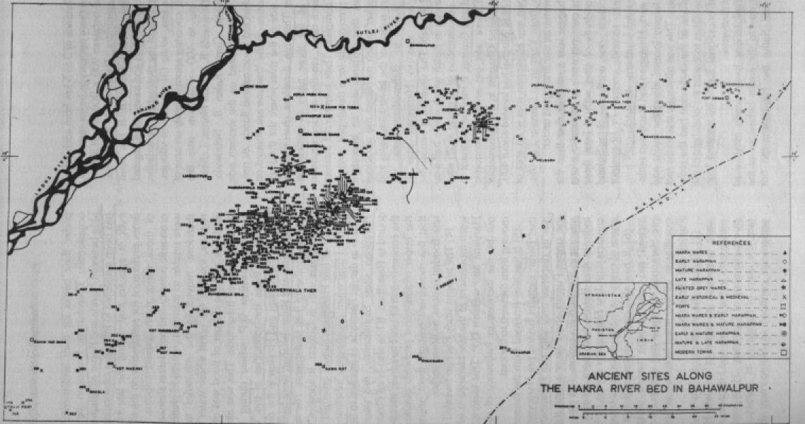
Sarasvati River sites in Bahawalpur Province (Mughal, 1984, p.515)
http://bharatkalyan97.

Vedic Saraswati River network in the late quaternary period from Manasarovar to Dwaraka: Perceived through Satellite Remote Sending by JR Sharma and Bidyut Bhadra, Regional Remote Sensing Centre, West NRSC/ISRO, Dept. of Space, Govt. of India, CAZRI campus, Jodhpur, Rajasthan (23 Feb. 2014) http://serveveda.org/3_JRS_B.pdf
![]()
![]()
![]()
![]()
![]()
![]()
![]()
![]()
![]()
![]()
![]()
![]()
![]()
![]()
![]()
![]()
![]()
![]()
![]()
![]()
![]()
![]()
![]()
![]()
![]()
![]()
![]()
![]()
![]()
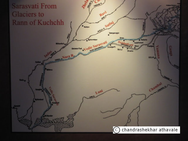
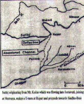
Saraswati River originated in the Himalayas and flowed
between Indus and Ganga through Punjab, Haryana,
western Rajasthan and Gujarat. It finally drained into
Arabian Sea.
Indus River – It originates from a glacier near Bokhar Chu in Tibetan region at an altitude of 4164m in Kailash Mountain Range.
Sutlej River – It originates from Rakas Lake at an altitude of 4555m in Tibet and is connected with Man Sarovar Lake by a stream.
Ganga River - It originates at Gangotri glacier near Gomukh in Garhwal Himalayas in Uttarakhand at an altitude of 3,900m in the central highlands.
Yamuna River - It rises at Yamunotri Glacier at an altitude of 3316m on Bandarpunch range and enters the Ganga plain.


Many seals of Indus Script Corpora signify a Supercargo, merchant's representative in charge of seafaring merchandise on a seafaring vessel. The hieroglyphs most frequently used to signify a Supercargo are: 1. Rim of jar and 2. Standing person with legs spread out. Both connote rebus karNi, 'supercargo'. Rakhigarhi on the banks of River Drishadvati, a tributary of River Sarasvati had seafaring trade with Ancient Near East as evidenced by the discovery of a cylinder seal with Indus Script (crocodile pictorial motif) discussed at http://bharatkalyan97.
S. kalyanaraman
Sarasvati Research Center
May 30, 2016