Mirror: http://tinyurl.com/hmgm93z
I have suggested that the entire Indus Script Corpora are metalwork catalogues. I have also hypothesised that Vedic Soma is processing of metal in fire while Avestan Haoma is a ritual drink venerting sacred waters. One Gonur seal with Indus Script holds the key to validate this hypothesis.
Many excerpts from the Zoroastrian heritage website are embedded.
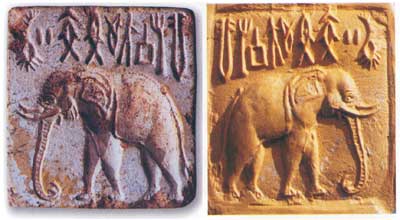
 Seal from Anau with unknown markings (may relate to Indus Script hieroglyhs)
 Inscription. Altyn Depe seal.
 Altyn-depe. Silver seal. Pictograph of ligatured animal with three heads.
 Two seals found at Altyn-depe (Excavation 9 and 7) found in the shrine and in the 'elite quarter'
Altyn-depe (No. 32 on the map) Bronze age seals (items 1 to 3 and 7 to 9) and motifs on Eneolithic (between the late 4th and the late 3rd millennia BCE) painted pottery of southern Turkmenistan (items 4 to 6 and 10 to 12) (After Fig 26 in: Masson, VM, 1988, Altyn-Depe, UPenn Museum of Archaeology)

Comparison of Altyn-depe statuettes and Early Harappan writing (After Fig. 24 in ibid.)
Gonur Tepe.Indus Script. Seal, Seal impression. Decipherment:
 This is a unique hypertext composed of a crucible PLUS a sprig. The sprig compares with the sprig inscribed on the exquisite terracotta image found at Altyn Tepe
Votive figure from Altyn-Depe (the Golden Hill), Turkmenistan. Altyn-Depe is an ancient settlement of the Bronze Age (3,000 - 2,000 B.C.E.) on the territory of ancient Abiver. It's known locally as the "Turkmen Stonehenge". União Soviética.
I suggest that this figure has inscribed Indus Script hypertexts read rebus related to metal smelting of elements, aduru 'native metal' and metal implements work.
Hieroglyph: kola 'woman' (Nahali) rebus: kol 'working in iron'
Hieroglyph: Ka. (Hav.) aḍaru twig; (Bark.) aḍïrï small and thin branch of a tree; (Gowda) aḍəri small branches. Tu. aḍaru twig.(DEDR 67) Rebus: Ta. ayil iron. Ma. ayir, ayiram any ore. Ka. aduru native metal. Tu. ajirda karba very hard iron. (DEDR 192)
Two hair strands signify: dula 'pair' rebus: dul 'metal casting' PLUS Hieroglyph
strand (of hair): dhāˊtu *strand of rope ʼ (cf. tridhāˊtu -- ʻ threefold ʼ RV.,ayugdhātu -- ʻ having an uneven number of strands ʼ KātyŚr.). [√dhā ]S. dhāī f. ʻ wisp of fibres added from time to time to a rope that is being twisted ʼ, L. dhāī˜ f. (CDIAL 6773)
Rebus: dhāvḍī 'iron smelting': Shgh. ċīw, ċōw, ċū ʻ single hair ʼ ; Ash. dro ʻ woman's hair ʼ, Kt. drū, Wg.drū, drū̃; Pr. ḍui ʻ a hair ʼ; Kho. dro(h) ʻ hair ʼ, (Lor.) ʻ hair (of animal), body hair (human) ʼ: → Orm. dra , drī IIFL i 392 (semant. cf. Psht. pal ʻ fringe of hair over forehead ʼ < *pata -- (CDIAL 6623) drava द्रव [p= 500,3] flowing , fluid , dropping , dripping , trickling or overflowing with (comp.) Ka1t2h. Mn.MBh. Ka1v. fused , liquefied , melted W. m. distilling , trickling , fluidity Bha1sha1p. dhāˊtu n. ʻ substance ʼ RV., m. ʻ element ʼ MBh., ʻ metal, mineral, ore (esp. of a red colour) ʼ Pa. dhātu -- m. ʻ element, ashes of the dead, relic ʼ; KharI. dhatu ʻ relic ʼ; Pk. dhāu -- m. ʻ metal, red chalk ʼ; N. dhāu ʻ ore (esp. of copper) ʼ; Or. ḍhāu ʻ red chalk, red ochre ʼ (whence ḍhāuā ʻ reddish ʼ; M. dhāū, dhāv m.f. ʻ a partic. soft red stone ʼ (whence dhā̆vaḍ m. ʻ a caste of iron -- smelters ʼ, dhāvḍī ʻ composed of or relating to iron ʼ)(CDIAL 6773)
Hieroglyph: *mēṇḍhī ʻ lock of hair, curl ʼ. [Cf. *mēṇḍha -- 1 s.v. *miḍḍa -- ]
S. mī˜ḍhī f., °ḍho m. ʻ braid in a woman's hair ʼ, L. mē̃ḍhī f.; G. mĩḍlɔ, miḍ° m. ʻ braid of hair on a girl's forehead ʼ; M. meḍhā m. ʻ curl, snarl, twist or tangle in cord or thread ʼ.(CDIAL 10312) Ta. miṭai (-v-, -nt-) to weave as a mat, etc. Ma. miṭayuka to plait, braid, twist, wattle; miṭaccal plaiting, etc.; miṭappu tuft of hair; miṭalascreen or wicket, ōlas plaited together. Ka. meḍaṟu to plait as screens, etc. (Hav.) maḍe to knit, weave (as a basket); (Gowda) mEḍi plait. Ga.(S.3 ) miṭṭe a female hair-style. Go. (Mu.) mihc- to plait (hair) (Voc. 2850).(DEDR 4853) Rebus: mẽṛhẽt, meḍ 'iron' (Santali.Mu.Ho.)
Three lines below the belly of the figure: kolom 'three' rebus: kolimi 'smithy, forge'
Hieroglyph: kuṭhi ‘vagina’ Rebus: kuṭhi ‘smelter furnace’ (Santali) kuṛī f. ‘fireplace’ (H.); krvṛi f. ‘granary (WPah.); kuṛī, kuṛo house, building’(Ku.)(CDIAL 3232) kuṭi ‘hut made of boughs’ (Skt.) guḍi temple (Telugu) kuṭhi ‘a furnace for smelting iron ore to smelt iron’; kolheko kuṭhieda koles smelt iron (Santali) kuṭhi, kuṭi (Or.; Sad. koṭhi) (1) the smelting furnace of the blacksmith; kuṭire bica duljad.ko talkena, they were feeding the furnace with ore; (2) the name of ēkuṭi has been given to the fire which, in lac factories, warms the water bath for softening the lac so that it can be spread into sheets; to make a smelting furnace; kuṭhi-o of a smelting furnace, to be made; the smelting furnace of the blacksmith is made of mud, cone-shaped, 2’ 6” dia. At the base and 1’ 6” at the top. The hole in the centre, into which the mixture of charcoal and iron ore is poured, is about 6” to 7” in dia. At the base it has two holes, a smaller one into which the nozzle of the bellow is inserted, as seen in fig. 1, and a larger one on the opposite side through which the molten iron flows out into a cavity (Mundari) kuṭhi = a factory; lil kuṭhi = an indigo factory (koṭhi - Hindi) (Santali.Bodding) kuṭhi = an earthen furnace for smelting iron; make do., smelt iron; kolheko do kuṭhi benaokate baliko dhukana, the Kolhes build an earthen furnace and smelt iron-ore, blowing the bellows; tehen:ko kuṭhi yet kana, they are working (or building) the furnace to-day (H. koṭhī ) (Santali. Bodding) kuṭṭhita = hot, sweltering; molten (of tamba, cp. uttatta)(Pali.lex.) uttatta (ut + tapta) = heated, of metals: molten, refined; shining, splendid, pure (Pali.lex.) kuṭṭakam, kuṭṭukam = cauldron (Ma.); kuṭṭuva = big copper pot for heating water (Kod.)(DEDR 1668). gudgā to blaze; gud.va flame (Man.d); gudva, gūdūvwa, guduwa id. (Kuwi)(DEDR 1715). dāntar-kuṭha = fireplace (Sv.); kōti wooden vessel for mixing yeast (Sh.); kōlhā house with mud roof and walls, granary (P.); kuṭhī factory (A.); koṭhābrick-built house (B.); kuṭhī bank, granary (B.); koṭho jar in which indigo is stored, warehouse (G.); koṭhīlare earthen jar, factory (G.); kuṭhī granary, factory (M.)(CDIAL 3546). koṭho = a warehouse; a revenue office, in which dues are paid and collected; koṭhī a store-room; a factory (Gujarat) koḍ = the place where artisans work (Gujarati)
Hieroglyph: sprig: ḍāla 5546 ḍāla1 m. ʻ branch ʼ Śīl. 2. *ṭhāla -- . 3. *ḍāḍha -- . [Poss. same as *dāla -- 1 and dāra -- 1 : √dal, √d&rcirclemacr; . But variation of form supports PMWS 64 ← Mu.]1. Pk. ḍāla -- n. ʻ branch ʼ; S. ḍ̠āru m. ʻ large branch ʼ, ḍ̠ārī f. ʻ branch ʼ; P. ḍāl m. ʻ branch ʼ, °lā m. ʻ large do. ʼ, °lī f. ʻ twig ʼ; WPah. bhal. ḍām. ʻ branch ʼ; Ku. ḍālo m. ʻ tree ʼ; N. ḍālo ʻ branch ʼ, A. B. ḍāl, Or. ḍāḷa; Mth. ḍār ʻ branch ʼ, °ri ʻ twig ʼ; Aw. lakh. ḍār ʻ branch ʼ, H. ḍāl, °lām., G. ḍāḷi , °ḷī f., °ḷũ n.2. A. ṭhāl ʻ branch ʼ, °li ʻ twig ʼ; H. ṭhāl, °lā m. ʻ leafy branch (esp. one lopped off) ʼ.3. Bhoj. ḍāṛhī ʻ branch ʼ; M. ḍāhaḷ m. ʻ loppings of trees ʼ, ḍāhḷā m. ʻ leafy branch ʼ, °ḷī f. ʻ twig ʼ, ḍhāḷā m. ʻ sprig ʼ, °ḷī f. ʻ branch ʼ.*ḍāla -- 2 ʻ basket ʼ see *ḍalla -- 2 .ḍālima -- see dāḍima -- .*ḍāva -- 1 ʻ box ʼ see *ḍabba -- .*ḍāva -- 2 ʻ left ʼ see *ḍavva -- .Addenda: ḍāla -- 1 . 1. S.kcch. ḍār f. ʻ branch of a tree ʼ; WPah.kṭg. ḍāḷ m. ʻ tree ʼ, J. ḍā'l m.; kṭg. ḍaḷi f. ʻ branch, stalk ʼ, ḍaḷṭi f. ʻ shoot ʼ; A. ḍāl(phonet. d -- ) ʻ branch ʼ AFD 207.टाळा (p. 196) ṭāḷā ...2 Averting or preventing (of a trouble or an evil). 3 The roof of the mouth. 4 R (Usually टाहळा) A small leafy branch; a spray or sprig. टाळी (p. 196) ṭāḷī f R (Usually टाहळी) A small leafy branch, a sprig.ढगळा (p. 204) ḍhagaḷā m R A small leafy branch; a sprig or spray. डगळा or डघळा (p. 201) ḍagaḷā or ḍaghaḷā m A tender and leafy branch: also a sprig or spray. डांगशी (p. 202) ḍāṅgaśī f C A small branch, a sprig, a spray. डांगळी (p. 202) ḍāṅgaḷī f A small branch, a sprig or spray. डाहळा (p. 202) ḍāhaḷā लांख esp. the first. 2 (dim. डाहळी f A sprig or twig.) A leafy branch. Pr. धरायाला डाहळी न बसायाला सावली Used.
Rebus: ḍhāla 'large ingot' (Gujarati)
karibha 'trunk of elephant' rebus: karba 'iron' ibha 'elephant' rebus: ib 'iron' Hieroglyph: ingot out of crucible: muh 'ingot' kuThAru 'crucible' rebus:kuThAru 'armourer' kolmo 'rice plant' rebus:kolimi 'smithy, forge'. Thus ingot for forge. sal 'splinter'rebus: sal 'workshop' aDaren 'lid' rebus: aduru 'native metal' aya, ayo 'fish' rebus: aya 'iron' ayas 'metal' khambhaṛā''fish-fin' rebus: kammaTa 'mint, coiner, coinage'. Hieroglyph: kāmṭhiyɔ m. ʻ archer ʼ.rebus: kammaTa 'mint, coin, coiner' ranku 'liquid measure' rebus: ranku 'tin' kolmo 'rice plant' rebus: kolimi 'smithy, forge' karNaka, kanka 'rim of jar' rebus: karNI 'Supercargo' karnaka 'engraver, scribe'.
Antenna hilted swords from Bactria compare with Fatehgarh copper hoard sword (See comments of BB Lal at http://archaeologyonline.net/artifacts/19th-century-paradigms-5):
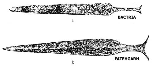
The metalwork in Gonur Tepe may explain the presence of Fatehbad type of sword in Gonur Tepe caused by migrations of people from Sarasvati-Sindhu river valleys into the Gonur region. Migrations are attested in Baudhāyana-Śrautasūtra Chapter XVIII.44 contains an important reference attesting to the migrations of two groups of people away from Kurukshetra region (Sarasvati River basin).
"Translation of BSS XIII.44: Ayu migrated eastwards. His (people) are the Kuru-Pancalas and the Kasi-Videhas. This is the Ayava (migration). Amavasu migrated westwards. His (people) are the Ghandhari, Parsu and Aratta. This is the Amavasu (migration).
"According to the correct translation, there was no movement of the Aryan people from anywhere in the north-west. On the other hand, the evidence indicates that it was from an intermediary point that some of the Aryan tribes went eastwards and other westwards.
This would be clear from the map that follows, noted BB Lal (2009).

See: http://bharatkalyan97.blogspot.in/2016/07/indus-script-gonur-tepe-seal-hypertexts.html
 |
| Archaeological sites along the northern foothills of the Kopet Dag Mountains Image credit: A Central Asian village at the dawn of civilization, excavations at Anau, Turkmenistan by Fredrik Talmage Hiebert, Kakamurad Kurbansakhatov, Hubert Schmidt |
S.Kalyanaraman
Sarasvati Research Center
August 30, 2016
See: Notes on Turkmenistan religion: http://www.heritageinstitute.com/zoroastrianism/turkmenistan/index.htm
|
 |
| Murgab delta and oasis (circled) in the south of Turkmenistan The Murgab river spreads out and disappears into the Kara Kum desert to the north |
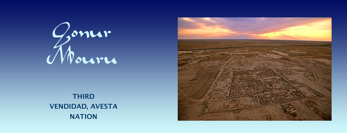
The Ancient Civilization of Mouru & the Murgab River Delta
 in the Murgab Delta") |
| Distribution of archaeological sites (in red) in the Murgab Delta Photo credit: University of Bologna |
The environs of Mouru, the third nation listed in the Zoroastrian scriptures, theAvesta's book of Vendidad, are generally thought to have included the Murgab river delta, that is, the region around Merv which today is a city in southern Turkmenistan. Ruins of over 150 ancient settlements dating back to the early Bronze Age (2500-1700 BCE) have been found in the Murgab delta region which covers an area of more than 3000 sq. km. and contains about 78 oases.
Archaeological reports indicate that the earliest agricultural settlements in the Murgab delta could date as far back as the 7th millennium BCE making it a seat of one of the oldest human civilizations - a civilization that Raphael Pumpelly (1837-1923) had sought to bring to the attention of a world more focused on the old civilizations of the Tigris-Euphrates and Nile River valleys, saying, "the fundamentals of European civilization—organized village life, agriculture, domestication of animals, weaving, etc. - were originated on the oases of Central Asia long before the time of Babylon." [Discover Magazine notes: " Volunteer Lisa Pumpelli is working there in a trench at the top of a large mound with a spectacular view of the Kopet-Dag mountains. She is helping Hiebert, who is now an archaeologist with the National Geographic Society in Washington, D.C., track down the precursors to the Oxus culture. Both are following in the footsteps of Lisa Pumpelli's grandfather, Raphael Pumpelly, and great-grandfather, also named Raphael Pumpelly (Pumpelly is an alternate spelling of the family name). "I'm digging in my great-grandfather's back dirt," Pumpelli quips."]
The River Murgab (also spelt Morghab, Murghab - or Murgap in the Turkmen language) originates on the western slopes of the Kuh-e Hissar mountains of northern Afghanistan. After flowing 850 kilometres - first to the west in the valley between Safeed Kuh and Siah Kuh mountains, and then to the north as it leaves Afghanistan to enter Turkmenistan - the once mighty river disperses itself as the fingers of a delta that disappears in the sands of Turkmenistan's Karakum (Garagum) Desert.
Verse 10.14 of the Avesta's Mehr Yasht, states that the rivers which originate in Airyo shayanem, the Aryan abode, flow swiftly into the countries of Mourum [later Margu(sh) (English-Greek Margiana) and eventually Marv located in today's Turkmenistan],Haroyum (Aria in modern Afghanistan), Sughdhem (Sugd in Tajikistan and Uzbekistan) and Khairizem [Khvarizem beside the Amu Darya (Oxus) River in Uzbekistan]. The principal river that flows into Mourum is the Murgab.
Ruins of the earliest of the Murgab delta settlements - those dating from the 3rd and 2nd millennium BCE - have been found in substantial numbers in the northeast of the delta region (see the image to the right) - a region that was once green and fertile but which today has been claimed by the relentlessly spread of the Karakum desert. The northern delta settlements include those now known as the ruins at Kelleli, Adji Kui, Taip, Gonur, and Togolok (Togoluk). The development of relatively advanced irrigation techniques in the early Iron Age enabled the growth of additional settlements. It is presumed that as the northern delta area became more dry, large metropolises like Gonur were abandoned. Further to the south, the ancient city of Mervbecame an Achaemenid era (519-331 BCE) administrative centre and perhaps even the capital of the satrapy that included Mouru. Mouru was then known to the Achaemenians as Margu(sh) and to the Greeks as Μαργιανή. Margiana is the derived English-Latin name of Margu. The Sassanian name for the region was Marv.
The ruins of Gonur are surrounded by other uncovered ancient settlements identified as dots in the images above and below.
 |
| Gonur & surrounding ancient settlements discovered so far |
The Region & Zoroastrianism
In the list of sixteen nations mentioned in the Zoroastrian scriptures', the Avesta's, book of Vendidad, Mouru or Mourum, is the third. Zarathushtra (Zoroaster) was native to Airyanam Vaeja (Ancient Aryana), the first in the list of the Vendidad-Avesta nations. Even though Zarathushtra was not native to Mouru, it is in the realm of possibilities that he might have preached in Mouru. However, this activity - if it took place - is not mentioned in the scriptures.
In listing the nations listed after Airyana Vaeja, the Vendidad cites non-Zoroastrian traits in many of the nations, suggesting that that the Aryan Zoroastrians possibly lived in multi-cultural multi-faith communities. Because ancient Zoroastrians did not worship in temples, because they did not bury their dead, and because they were careful not to defile the environment with garbage, they would have left scant evidence of their religious activities.
What we learn from the archaeological findings under the tepe or depes in the Murgab region supports the history contained in the Avesta, a history we have outlined in our pages on the Aryans.
Tepe or Depe
'Tepe' or 'depe' is a Turkoman word for a mound and is synonymous with the word 'tell', used in the Middle East to denote mounds or small hills. In treeless areas, such geographic features often indicate the presence of buried ancient settlements formed from mud-brick structures compressed over time by later human occupation and later still by soil into artificial hills. If the tepes contain ruins of settlements built one on top of the other, excavations reveal layers of settlements that can be dated using modern laboratory techniques. The lower layers are therefore normally the older layers.
The largest of the settlements uncovered in the north-eastern Murgab delta are the ruins called Gonur-Tepe. We have not read to any layers in this excavation as of this writing though it it quite possible that lower, older, layers await discovery.
The largest of the settlements uncovered in the north-eastern Murgab delta are the ruins called Gonur-Tepe. We have not read to any layers in this excavation as of this writing though it it quite possible that lower, older, layers await discovery.
Gonur / Gonor/ Gunar
The Archaeological Site
|


 |
| Another reconstruction of the Gonur north complex. Artist unknown |
The largest of all the ancient settlements uncovered in the Murgab delta is Gonur-Depe (or Gonur-Tepe. Gonur is also spelt Gonor or Gunar). Gonur is located some seventy kilometres north of the ruins of Merv and a three-hour drive from Mary. The area around Gonur is now sparsely populated.
The Gonur site occupies an area of about 55 hectares and consists of the main complex in the northern section of the site and a smaller (130 x 120 m = 1.56 hectare) complex to the south.
The southern complex is also said to be 3 hectares in size and that might include surrounding structures.
A large necropolis lies to the west of the site. In the centre of the northern complex is a fortified citadel-like structure. Both complexes have fortification walls. The fortification walls of the southern complex are wide, 8 to 10 metres tall and interspaced with round towers along its sides and corners. There are residential quarters walls within the fortifications.
 |
| Aerial photo of Gonur showing both complexes (looking almost directly north). Photo credit: Kenneth Garrett |
 |
| Gonur south complex |
 |
| Reconstruction of the Gonur south fortifications at National Museum of Turkmenistan. Photo credit: Kerri-Jo Stewart at Flickr |
 |
| Reconstruction of the Gonur north citadel complex at National Museum of Turkmenistan. Photo credit: Kerri-Jo Stewart at Flickr |
 |
| Excavated Gonur north complex. Photo credit: Black Sands Film |
Reference:
Excavations at Southern Gonur, by V. Sarianidi, 1993, British Institute of Persian Studies.
» Brief History of Researches in Margiana by Museo-on
Other web articles include Discover Magazine, Anahita Gallery, Kar Po's Travel Blog, Dan & Mary's Monastery, Archaeology Online, Turkmenistan June 2006 and Stantours. Generally, we find the quality of research and reports available of the web to be poorly researched, highly speculative and sensationalistic.
Photo sites:
» Flickr
» Uncornered Market.
Description of Ancient Gonur
Gonur was a large town for the times and home to thousands of residents. It was for all practical purposes, a city, a metropolis. The city had carefully designed streets, drains, temples and homes. The people farmed the surrounding fields growing a wide variety of crops and produce that included wheat, barley, lentils, grapes and other fruit.
The people of Gonur were also traders and were likely among those who developed the first trade links between the East and the West along what came to be known as the Silk Roads. The good the traders carried to distant cities included those made from for ivory, gold, and silver. They buried their dead in elaborate graves filled with fine jewellery and wheeled carts.
The north Gonur complex had a central citadel-like structure about 100m by 180m (nearly 350 by 600 feet) in size and surrounded by a high fortification wall and towers. The citadel was set within another vast walled area. This wall had square bastions and was in turn placed within a large oval enclosed walled area that included a large water basins and many dwellings and other buildings.
The archaeologist Viktor Sarianidi (see Sarianidi, page 3) who excavated the ruins, began a trend to call Gonur, Margush (or the capital of Margush), a name used by the Achaemenians for Mouru or Merv a thousand or so years after Gonur had been abandoned. We would prefer to say that Gonur was a major administrative centre and metropolis of Mouru, the older Avestan name for the nation.
Sarianidi also identifies the southern structure as a cathedral-like temple. We strongly doubt this conclusion for Sarianidi's analysis has numerous factual errors and he displays no real knowledge of Zoroastrianism, its doctrine and practice on which he bases many of his conclusions. These errors and lack of understanding (or even an attempt at objective research) brings into question the credibility and veracity of his sensationalistic and outlandish pronouncements about the function of the various structures within the Gonur complexes.
The evidence from the excavations points to the city of Gonur functioning for the relatively short time of a few hundred years after which it was abandoned by its residents.
Water Management
There appears to have been a natural or artificial reservoir beside the city and within its outer walls. The surrounding fields and orchards were watered using lengthy canals that the residents had dug from the glacier-fed arms of the Murgab River delta. Since the rivers were fed by glaciers and since the framers did not have to rely on rain for irrigation, their crops were not threatened by drought.
In addition to the water canals the residents of Gonur had dug from the river to water their fields, the city also had a sophisticated water supply and sewage system. it appears water was brought in to the city. The city also appears that two separate sewage systems, one for ordinary waste water and the other - it is suggested - for water that had been used for the ritual washing of bodies during funerals. Given Sarianidi's other fantastic and ill-informed conclusions about Zoroastrian rites, we must wonder about the veracity of this construct.
Temple
 |
| So-called Temple(?) building walls with three narrow rooms to the left being uncovered in Gonur-Depe Photo credit: Country Turkmenistan |
A web article posted by State News Agency of Turkmenistan, quotes Viktor Sarianidi (see Sarianidi, page 3) leader of the Gonur excavations, as stating that in the spring of 2006, his team uncovered a large temple building near the central palace. Sarianidi dated the building and functioning of structure to between the late 3rd to early 2nd millennium BCE.
The Turkmenistan State News Agency article describes the building uncovered in 2006 as "a monumental building remarkable for the strict geometrical forms and brilliant architectural design. The central part of the "shrine" (sic) which has the walls sometimes 1.5 meters thick and strictly oriented to the sides of horizon is of particular interest. The rooms have the complementary angles. The principles of planning some architectural blocks indicate the specific purposes of using the temple complex. E.g., three single-type corridor-like rooms directly correspond to the architectural design of monumental constructions in the ancient Orient." We note that the contorted language used in the report makes a clear understanding of its contents difficult.
In the photograph of the excavated rooms of the "temple" shown above right, the larger room has a circular foundation which the Turkmenistan new agency article describes as a "furnace" with an inner and outer chamber. The inner chamber contained burnt material presumably residue of the fuel used but which the article does not identify. The article further notes that pots found in the vicinity of the building had an internal lining that made them waterproof, thereby making them capable of holding liquids.
As we have stated earlier, we have serious concerns about the conclusions reached by Sarianidi some of which we know to be factually incorrect. Others scientists have not only failed to verify Sarianidi's claims to have discovered residues of narcotic substances stored in containers within these "temples" (sic), but have also identified the residues of impressions of the seeds stored within the containers as a food grain.
Sarianidi has been obsessed with the notion that the primary function of the "temple" was to support the ritual of preparing a narcotic which he describes as the Zoroastrian haoma. We discuss the absurdity of this notion below. He also states that these so-called temples at Togolok-21 and Gonur "had fire altars as well, that were always located in secret places inside the temples and were hidden behind high blind walls."
We should keep in mind that the early Zoroastrians did not as far as we know construct urban temples. In any event, Zoroastrians have never at any time constructed temples to produce a narcotic - never. That suggestion is highly insulting to Zoroastrians.
Speculation About the Use of Haoma
The State News Agency of Turkmenistan article cited above quoting Sarianidi, further states that the archaeologists found evidence that a haoma-like ritual (according to their bizarre understanding of haoma & Zoroastrianism) was performed in one of the Gonur buildings. This understanding includes haoma being a narcotic - something that is entirely bogus. There is no evidence whatsoever of haoma ever being a narcotic. Haoma used in Zoroastrian rituals is made from a small quantity of natural ephedra and pomegranate stems and the entire haoma system is intended to promote health and vitality only. In addition, the veracity of Sarianidi's speculations and conclusions is disputed by scientists (Hiebert 1994: 123-129; Parpola 1998: 127;) using more credible analysis techniques (at the laboratory of the Helsinki University). The sensationalistic claims by Viktor Sarianidi (see Sarianidi, page 3) proclaiming the discover of narcotic material with completely unsubstantiated links with the haoma ritual were found after a more careful study to be implausible. [Click here for the article by Viktor Sarianidi titled Margiana and Soma-Haomapublished in the electronic Journal of Vedic Studies (EJVS) Vol. 9 (2003) Issue 1d (May 5) and with Jan E.M. Houben of Leiden University as Guest Editor. We note that Sarianidi's references do not include a single authentic Zoroastrian source even though he claims to associate certain findings with Zoroastrianism.]
According to James P. Mallory 1989 & 1997 "... remains of ephedras have also been reported from the temple-fortress complex of Togolok 21 in the Merv oasis (ancient Margiana – Parpola 1988; Meier-Melikyan 1990) along with the remains of poppies. ... In 1990 I received some samples from the site [forwarded by Dr. Fred Hiebert of Harvard University], which were subjected to pollen analysis at the Department of Botany, University of Helsinki. .... The largest amount of pollen was found in the bone tube (used for imbibing liquid?) from Gonur 1, but even in this sample, which had been preserved in a comparatively sheltered position when compared with the other investigated samples, only pollen of the family Caryophyllaceae was present. No pollen from ephedras or poppies was found and even the pollen left in the samples showed clear traces of deterioration (typical in ancient pollen having been preserved in a dry environment in contact with oxygen). Our pollen analysis was carefully checked for any methodological errors, but no inaccuracies were found."
Yet another refutation of Sarianidi's wild and unsubstantiated claims of 1. having found narcotics and 2. associating what he found is found with haoma and thereby a Zoroastrian cult (sic) ritual is found in a journal article of which Jan E.M. Houben of Leiden University, Netherlands [E. Journal of Vedic Studies Vol. 9 (2003) Issue 1c (May 5)]. [Click here for an excerpt of the article by Professor C.C. Bakels titled Report concerning the contents of a ceramic vessel found in the "white room" of the Gonur Temenos, Merv Oasis, Turkmenistan.] Bakels concludes, "The material we examined contained broomcorn millet. This cereal is known from the Merv oasis, at least from the Bronze Age onwards (Nesbitt 1997). The crop plant most probably has its origin in Central Asia, perhaps even in the Aralo-Caspian basin."
Professor Houben states, "After a few months I received messages indicating that no proof could be found of any of the substances indicated by Sarianidi. Rather than hastily sticking to this conclusion, Prof. Bakels made efforts to show the specimens to other paleobotanists whom she met at international professional meetings. At the end of this lengthy procedure, no confirmation could be given of the presence of the mentioned plants in the material that was investigated. The traces of plant-substances rather pointed in the direction of a kind of millet."
We must also wonder on what basis Sarianidi and his cohorts came to the conclusion that some of the building were part of a temple complex. The containers that Sarianidi claims stored narcotics were simply grain containers, the likes of which are found all over the region. Any oven in the same building could have been used to cook or bake bread. What Sarianidi and his cohorts fancy to be a temple could have been a bakery.
When the careful analysis of the residues in pots did not support Sarianidi claims of the discovery of narcotic substances, the excuse offered is that the vessels are now exposed to the sun and the evidence has been destroyed. Unfortunately, this excuse uncovers yet another problem with Sarianidi excavations - careless exposure of the artefacts and the ruins.
The speculation guised as an assertion regarding the preparation and use of haoma / hom in Gonur is bad enough. The association of haoma with a narcotic is pathetic - a thoughtless imaginary construct which is deeply insulting to Zoroastrians and Zoroastrianism.
These so-called archaeologists who know little about Zoroastrianism other than what they read in some fanciful books, should refrain from their wild and sensational speculation that does a great deal of harm to Zoroastrians and Zoroastrianism. Their energies would be better directed at using best practices in digging up buried history that is being destroyed by careless and disgraceful methods.
Claims Regarding Gonur/Margush/Turkmenistan as the Birthplace of Zoroaster or Zoroastrianism
If the absurd claims regarding Haoma were not bad enough, Sarianidi is quoted as claiming that either Gonur, Margush or Turkmenistan were the birthplace of Zoroastrianism and Zarathushtra (Zoroaster) himself.
The online article published by State News Agency of Turkmenistan as well as Turkmenistan's Federal Service for Supervision of Compliance with Legislation Governing Mass Communications and Protection of Cultural Heritage - the article cited above carries the heading: Professor V. I. Sarianidi: "The First World Religion - Zoroastrianism - Emerged In Turkmenistan". Apparently quoting Sarianidi, the article goes on to state:
"The people in Turkmenistan and other countries know the words from Ruhnama (*see below), "Two and a half thousand years ago Zarathushtra from Margush appeared in the world. Reining his sorrel camel he exclaimed, "People, worship Fire, its sources will lead you along the right path, illuminate each nook in your souls!" For all these years we have been uncovering the tangible evidence proving that there, in the old delta of the Murghab River, the oldest religion in the world Zoroastrianism emerged. The spring archelogical (their spelling, not ours) season (headed by Viktor Sarianidi) ended in uncovering a monumental temple building near the central palace in Gonur-depe. The building is linked with the process of cooking a ritual drink of importance among ancient Zoroastrians which is mentioned Avesta (the Zoroastrian scriptures) as Haoma....
[* Note the Ruhnama means "The Book of the Soul" according to Wikipedia, which goes on to say, "...is a book written by Saparmurat Niyazov, late President for Life of Turkmenistan, combining spiritual/moral guidance, autobiography and revisionist history; much of it is of dubious or disputed factuality and accuracy. Further, "It was mandatory to read the Ruhnama in schools, universities and governmental organizations. New governmental employees were tested on the book at job interviews.""In March 2006, Niyazov was recorded as saying that he had interceded with God to ensure that any student who read the book three times would automatically get into heaven." Sarianidi has also written a book titled Zoroastrianism: A New Motherland for an Old Religion.]
Amongst everything else, the apparent contradiction in the late President-for-life's statements that "Zarathushtra from Margush" lived 2,500 years ago (an incorrect date we may add) and Sarianidi's assertion that Gonur was abandoned a thousand or so years before that date, seems to escape the proponents of this fantasy.
While not mentioned in the Avesta, it is in the realm of possibilities that Zarathushtra (Zoroaster) could have conducted a ministry in or near Gonur - and elsewhere in the vicinity as well. And while Zoroastrians could have lived in the vicinity of Gonur, there is no basis for the claim that Zarathushtra was born in, or that Zoroastrianism originated in, Gonur, Margush or Turkmenistan. The Zoroastrian text, the Bundahishn at 20.32 states that Zarathushtra's father house was on the banks of the Daraja River in Airan-Vej (Airyana-Veja, the first nation of the Avesta-Vendidad's list of sixteen nations) and at 32.3 it states that Zarathushtra, when he brought the religion, first celebrated worship and expounded (the religion) in Airan-Vej. The Avesta's Farvardin Yasht at 13.143 & 144 list individuals who were the first "hearers and teachers" of Zarathushtra's teachings as from five nations: Airyana-Vaeja (called Airyanam Dakhyunam in the Yasht), Tuirya, Sairima, Saini and Dahi. The Farvardin Yasht extols Vishtasp as accepting the faith and the poet Ferdowsi's epic the Shahnameh states that Vishtasp was the King of Balkh (Bakhdhi), fourth in the Avesta-Vendidad list of nations and Mouru's northern neighbour.
Mouru (the predecessor nation to Margu(sh) and eventually Turkmenistan) is not mentioned at all in the context of being part of Zarathushtra's ministry. Mouru, the third Avestan nation was likely a neighbouring nation to Airyana-Vaeja, the first Avestan nation and Zarathushtra's birthplace, and Mouru was certainly close to Balkh (Bakhdhi), the fourth Avestan nation.
In conclusion, was Gonur while it existed Zoroastrian? Possibly - depending on the date you feel Zarathushtra established his religion. Was the Murgab delta, Mouru, part of the greater Aryan federation? Yes. Was the Murgab delta, Mouru, a nation with early Zoroastrians? Most likely. Was the Murgab delta, Mouru, the birthplace of Zarathushtra/Zoroaster or Zoroastrianism? No.
Necropolis & Burial Customs
 |
| Pit grave in the necropolis Ceramic vessels & a bronze mirror lie next to the skull |
In one section of Gonur North, is a burial site, the necropolis, west of the palace site, containing mostly small children buried in pots. An article by Kate Fitz Gibbonof Anahita Gallery states:
"Their tiny, newborn bones are so fragile that they crumble at a touch. The beautiful Bronze Age beads from plundered sites in Afghanistan have long fascinated me. Most often, buried bead materials are found in vessels placed close to the body, and as any stringing material has long since disintegrated with age, it is not even possible to guess how they were worn. In the Gonur Tepe palace, an unexpected find of a youth buried inside a large ceramic vessel included not only rich grave goods, but also clues as to how some beads were worn. Skull and neck vertebrae were held together with hardened mud, and as the dirt was removed, lapis, talc and a single, inch and a half long carnelian bead carved in chevron patterns were found encircling the neck. A single gold earring was embedded near the ear, and a half-dozen large, finely polished banded agate beads lay in the bottom of the vessel in which the youth was buried.
"Their tiny, newborn bones are so fragile that they crumble at a touch. The beautiful Bronze Age beads from plundered sites in Afghanistan have long fascinated me. Most often, buried bead materials are found in vessels placed close to the body, and as any stringing material has long since disintegrated with age, it is not even possible to guess how they were worn. In the Gonur Tepe palace, an unexpected find of a youth buried inside a large ceramic vessel included not only rich grave goods, but also clues as to how some beads were worn. Skull and neck vertebrae were held together with hardened mud, and as the dirt was removed, lapis, talc and a single, inch and a half long carnelian bead carved in chevron patterns were found encircling the neck. A single gold earring was embedded near the ear, and a half-dozen large, finely polished banded agate beads lay in the bottom of the vessel in which the youth was buried.
 |
| An apparent royal burial site at Gonur contains luxury goods, a cart with bronze-sheathed wheels, and the remains of a camel. Photo Credit: various. tzaralunga at Flickr & Kenneth Garrett at Discover Magazine |
"My mother and I spent most of our days at Gonur in the large necropolis to the west of the palace site. We used fine brushes to remove the last of the dirt from the whitened bones and grave goods uncovered by the diggers. Each day, three or four grave pits were uncovered and cleared of dirt to the undisturbed earth - about four feet below the present surface. After each day's excavations at the necropolis, the pits were photographed and partially filled in again. Most skeletons appeared still to lie as they were buried; knees and elbows flexed, the head often resting on or near a small pile of ceramic and stone vessels. It was clear, however, that the necropolis had been robbed in antiquity. Very few items of jewellery were found, and in one grave, a fine, carved alabaster cylinder seal was unearthed under just a few inches of surface soil. A too hasty grave plunderer had apparently dropped it, several thousand years before."
Gonur's Exquisite Artefacts
The quality, artistry and workmanship of the artefacts unearthed at Gonur has surprised observers. They include intricate jewellery and metalwork incorporating gold, silver, lapis lazuli, and carnelian.
 |
| Necklace with carnelian obsidian beads found in the necropolis at Gonur. Carnelian is a hard reddish translucent semiprecious gemstone that is a variety of chalcedony, a form of banded quartz. Obsidian is a jet-black volcanic glass, chemically similar to granite and formed by the rapid cooling of molten lava. Photo credit: Anna Garner at Flickr. The beads are now part of Anna Garner's collection. |
 |
| Pin with camel ornament. Photo credit: Katy Tzaralunga at Flickr |
 |
| Fine containers. Photo credit: Katy Tzaralunga at Flickr |
") |
| Artistic wall decorations(?). Photo credit: Katy Tzaralunga at Flickr |
The prowess of the Gonur metalworkers - who used tin alloys and delicate combinations of gold and silver - were on par with the skills of their more famous contemporaries in Egypt, Mesopotamia, and the Indus Valley. Their creations display a rich repertoire of geometric designs, mythic monsters, and other creatures. Among them are striking humanoid statues with small heads and wide skirts, as well as horses, lions, snakes, and scorpions.
|
 of a griffin-like creature")
 of a griffin-like creature")
 |
| A rich find of pottery at Gonur. Photo credit: josephescu at Flickr |
 |
| Seal of the type found and used in the Indus Valley |
Gold and other metals are not found in the region. The lapis lazuli likely came from the Badakshan mountains that are now in the northwest of Afghanistan.
Wares in this distinctive style had long been found in regions far and near. As close as Gonur's southern neighbour Balkh in today's Afghanistan, and as far as Mesopotamia to the west, the shores of the Persian Gulf to the south, the Russian steppes to the north, and to the southeast across the Hindu Kush - the great cities of Harappa and Mohenjo Daro, which once flourished on the banks of the Indus River in today's Pakistan.
Archaeologists had long puzzled over the origin of the fine artefacts found in the Indus Valley and in the distant lands - artefacts made from materials not native to those areas. The Gonur excavations provide one possible answer: that the items originated in the region around Gonur. For the artefacts to have spread to lands thousands of kilometres apart indicate the presence of an active trade network consisting of artisans, traders, merchants, an extensive road network and possibly even bazaars. It is conceivable that the hub of the network was Central Asia and that Gonur lay at its heart. The merchants of Gonur and Central Asia could even have been the possible originators of the Silk Roads.
That all of this together in an advanced urban setting supported by an irrigated agricultural system was already developed and functioning in the Bronze Age (2500-1700 BCE) is astounding.
The Abandonment of Gonur
The archaeological artefacts found in Gonur's ruins are dated to a period that spans a few hundred years. During their excavations, archaeologists did not find artefact containing over-layers dated later than than the Bronze Age layer that contained Gonur's ruins. This has led researchers to surmise that Gonur was abandoned either for reasons of warfare or because of the receding waters of the Murgab, compelling residents to move towards Merv and the surrounding foothills.
In the Avesta's Vendidad, the virtues associated with the people of Mouru are that they were brave and holy. The evils associated with Mouru are plunder and bloodshed. We do not know if the people of Mouru engaged in bloodshed and plunder or if they were the victims of plundering aggressors. The fortifications at Gonur (three walls) are far more extensive that those found in other Aryan lands. Mehrgarh on the western Indus Valley slopes had no fortifications.
The people and nations of the Avesta, the Aryans, were a settled, organized people who farmed and lived in towns. Zoroastrian texts tell us that it is from the north that an ill wind blew and that brought with it a violent and destructive people who raided and plundered the towns of the Aryans.
To the north of the central Asian Aryan kingdoms lay deserts and grazing land inhabited by nomads, a pastoral people who relied on herds that were constantly on the move seeking new pastures. The nomads also hunted for their food and raided the settlements of their neighbours.
There is evidence that extensive fires destroyed some of Gonur's central buildings - building that they were never rebuilt.
Age, People & Culture
Prof. Fredrik Hiebert of the Univ. of Pennsylvania (who during the 1988-89 field season, excavated part of Gonur in collaboration with the Ministry of Culture of Turkmenistan and the Institute of Archaeology in Moscow), in his book Origins of the Bronze Age Oasis Civilization in Central Asia (Harvard University Press, 2004) writes on page 2:
"The archaeology of Margiana is fundamentally tied into the Kopet Dag foothill chronological framework of the Namazga culture (see note 1). Of prime importance has been the association of the monumental architecture in Margiana with numerous miniature stone columns, steatite bowls, bronze seals, and stone amulets. None of the materials of these objects is locally available (see note 2), yet they have a style distinctive to the desert oases of Margiana and Bactria. The oasis sites have provided the first known cultural context for the Bactrian-Margiana Archaeological Complex."
After earlier independent work by Soviet archaeologists that would have included Viktor Sarianidi, Hiebert worked with Sarianidi, an effort that resulted in a change of previous conclusions. Hiebert writes, "This study is based on collaborative excavations conducted by V. Sarianidi and myself (our note: misplaced reflective pronoun "myself" here – should be the object pronoun "me") at the Bronze Age site of Gonur Depe in Margiana. It is proposed that the rapid occupation of sites in the Murgab delta oasis was contemporary with the Namazga V settlement in the foothill region, which was the period of largest urban settlement at the site of Altyn Depe (see note 3). The present study proposes that the Bactrian-Margiana Archaeological Complex developed from local traditions at the beginning of the second millennium (our note: say 2,000 – 1,600 BCE see note 4). In contrast to previously suggested reconstructions of the origins of the Bactrian-Margiana Archaeological Complex, I show that this development does not result from migrations from Iran, South Asia, or Mesopotamia, nor from the sedentarization of nomads (see note 5).
"The diverse geography and natural resources of Central Asia form a framework for the pattern of human settlement. The differential development of culture in the areas of oasis and foothill plain is largely due to this diversity of environments.
"The archaeological context of the Bronze Age sites of Margiana is special, in that very little post-Bronze Age architectural remains are preserved just below the surface. The area is highly deflated, leaving little more than the ground plan and a small amount of deposit just above the floors. These have been cleared over wide areas, exposing entire building complexes."
"the oasis regions of ancient Bactria and Margiana developed their own artistic tradition on stone and metal artefacts despite the lack of natural resources on which they were made."
Note (general): It seems the Margians imported the raw material of the artefacts in main part from their southern Arian neighbours, the Bactrians and others, and then fashioned the artefacts for domestic use and export for the artefacts are reported to have been found in the Indus Valley. This activity points to a shared understanding between the Arian nations, a network of roads that connected them and policed to assure safe passage of the travellers, knowledge of tools suitable to work with the properties of different materials, and craft shops if not small factories. Aryan society would have had to be fairly complex, with agriculture supported by a network of canals, cities supported by a water and sewage distribution network, architects, builders of buildings and infrastructure, traders, administrators, a military and laws to govern society and keep the peace.
Note 1: Namazga or Namazgah (meaning prayer-place, "ga" is a contraction of "gah" meaning place) is a Bronze Age archaeological site in Turkmenistan, some 100 km from Ashgabat, near the Iranian border. Numbers in Roman numerals beside the name indicate the age of an excavation layer (at times settlements were rebuilt on top of previous ones). Namazgah IV is dated around 2,500 BCE, V to around 2,000-1,600 BCE, and VI to around 1,600-1,000 BCE.
Note 2: This phenomenon of the discovery of materials not native to an area is a common denominator of the various nations of Ancient Aryana who actively traded amongst themselves.
Note 3: Namazga(h) V is dated to around 2,500 BCE. An article (1989 updated 2011) by V. M. Mason at Iranica states, "The excavations (at Altyn Depe) show continuous development of an early agricultural culture from the 5th to the early 2nd millennium BCE Though a settlement of the Neolithic Jaitun culture (6th millennium BCE) is situated nearby… in the 4th millennium B.C. the inhabited area of Altyn Tepe increased to 12 hectares… at the end of the 4th to the early 3rd millennium B.C., Altyn Tepe covered 25 hectares, acquiring the character of a large inhabited center… Altyn Tepe reached its most flourishing stage at the end of the 3rd-early 2nd millennium B.C. (complex of the Namazga V type), when it was a settlement of the early urban type."
Note 4. Hiebert notes on page 2, "The previous radiocarbon dates from Margiana and from other areas of Central Asia have provided unsatisfactory results for archaeologists." (Hiebert's) "chronology is based primarily on a new series of radiocarbon dates, which came from the Margiana excavations, both from my own excavations and from previous excavations."
The residents of Gonur did not, however, materialize from nowhere. They were residents of the area who built Gonur. We do not know if any lower excavation layers have been found.
Note 5: Saka and Turkic migrations occurred later – after Alexander’s invasion and subsequent occupation weakened the infrastructure. Nomadic raids from the north were constant – thus the fortifications. The raids were for plunder and not for settlement (the nomads had no interest in settling and working for a living).
According to Discover Magazine, "Fredrik Hiebert, a young American graduate student, learned Russian, visited Gonur in 1988, and then a few years later returned with his Harvard adviser, Lamberg-Karlovksy. A team of Italians followed to dig at nearby sites and to examine Gonur's extensive cemetery."
Kelleli
As with Gonur, Kelleli is a Bronze Age (2500-1200 BCE) settlement located some 40 km northwest of Gonur. The settlement has two major sites: Kelleli 3 and 4. Kelleli 3 is four hectares in size and had double external wall with towers flanking four symmetrical entrances. In the south-western sector, is an area of houses. Kelleli 4 is three hectares in size and also has a double outer wall with towers. According to a UNESCO document, both sites are poorly preserved.
Toguluk / Togulok
 |
| Artist's reconstruction of Toguluk / Togulok |
|


Togolok consists of two sites, Togolok 1 and Togoluk 21. Togoluk 21 is the larger of the two sites. According to Viktor Sarianidi:
"The next and last shrine excavated is located in the settlement of Togolok 21, which dates to the late 2nd millennium. Taking into account its large overall size (larger than the fortress of South Gonur), it is possible that the shrine of Togolok 21 served the inhabitants of the whole country of Margiana in the late Bronze Age. Similar to the above-described shrines, there is a domestic area near Togolok 21 associated with the shrine. At Gonur depe and Togolok 1 the settlements are many times larger than the shrines, while in Togolok 21 the settlement is a great deal smaller than the shrine itself.
"The shrine of Togolok 21 was built at the top of a small natural hill. Along the outer face of the exterior wall are circular and semicircular hollow towers. In the northern part of the wall are two pylons between which a central gateway, supposed to be the entrance to the shrine, is located. The second entrance was built in the middle of the southern wall. The whole inner area was not built up except at the western side where some extremely narrow rooms are located which appear to have had arched ceilings. Their purpose is unclear. Two altar sites located opposite each other in the northern part of the shrine were perhaps used for carrying out ritual ceremonies associated with libations and fire rituals."
Adji Kui
Another Bronze Age (2500-1200 BCE) settlement Adji Kui is located about 13 km northwest of Gonur. The present site, Adji Kui 8, is about 8.5 hectares in size.
Taip
The ruins of Taip indicate that the settlement typifies the transition from a Middle Bronze Age form of settlement pattern to a Late Bronze Age settlement. Two close but distinct mounds consist of a 3.5 hectare walled square area with a large courtyard building in the south.
Very Poor Archaeological Practices
 |
| Thousands of pottery shards are scattered across the Gonur-depe excavation site. Visitors steps over these priceless artefacts further destroying a priceless treasure. Photo credit: Eurasianet.org |
The discovery of the ruins in the Merv region may be a mixed blessing. One the one hand the world has become aware of another centre of civilization. On the other hand, the very poor archaeological practices may be the cause of the speedy destruction of the evidence. The following is a quote from Eurasianet.org's article Turkmenistan: Making a Bid for Cradle-Of-Civilization Status
"In a painful irony, some of the dust that swirls around Gonur-depe comes from the crumbling walls themselves. To study the city, Sarianidi's team had to remove the protective earthen shield laid down over millennia, thereby exposing the structures beneath to the desert sun and wind. Indeed, today’s photographs of Gonur-depe show a significant deterioration when compared to those of the 1970s and 1980s."
"Without a greater commitment from the Turkmen state, funding will dry up, the guide said, and Gonur-depe will slowly blow away."
Also see:
» About Recent Excavations at a Bronze Age Site in Margiana by Sandro Salvatori (a rebuke and criticism of Rossi Mosmida's practices, ethics and book Adji Kui Oasis.
» Brief History of Researches in Margiana by Museo-on
Viktor Sarianidi
 |
| Viktor Sarianidi |
For over 30 years, Professor Viktor Sarianidi, Laureate of the Magtymguly International Prize and Doctor of History, has headed the Margiana Archaeological Expedition that has conducted excavations in Turkmenistan and other Central Asian states.
The sites include Namazga-Depe, Altyn-Depe, Delbarjin, the Dashly Oasis, Toholok 21, Gonur, Kelleli, Sapelli, and Djarkutan. In Gonur-Depe for instance, where others saw only sand and scrub, Sarianidi saw the remnants of a wealthy town protected by high walls and battlements. (Indeed all the sites have high protective walls.)
The sites include Namazga-Depe, Altyn-Depe, Delbarjin, the Dashly Oasis, Toholok 21, Gonur, Kelleli, Sapelli, and Djarkutan. In Gonur-Depe for instance, where others saw only sand and scrub, Sarianidi saw the remnants of a wealthy town protected by high walls and battlements. (Indeed all the sites have high protective walls.)
 |
| Ancient pottery carelessly strewn all over Sarianidi supervised sites |
While some researchers have applauded Sarianidi for his dedication, others view him as an eccentric, employing brutish and old-fashioned techniques. These days Western archaeologists typically unearth sites with dental instruments and mesh screens, meticulously sifting soil for traces of pollen, seeds, and ceramics. Sarianidi uses bulldozers to expose old foundations, largely ignores botanical finds, and publishes few details on layers, ceramics, and other mainstays of modern archaeology. Ceramics that he has unearthed and which for millennia have remained protected deep in the sand now lie strewn about his sites with visitors stepping over them as they walk around. Local residents and animals also climb all over the fragile earthen structures. His reports are also sensationalistic, conjectural and poorly researched. Sarianidi's conclusions are routinely contradicted by a more sober analysis. Nevertheless, his findings have provided rich fodder for those captivated by the fantasy generated by his claims. It is unfortunate that his lack of credibility by serious scholars may obscure his other accomplishments. A further tragedy that may overshadow his work is that paradoxically he may have done a disservice in unearthing the ruins. The exposed ruins have been left with no protection and are being rapidly eroded.
As a Greek growing up in Tashkent, Uzbekistan, under Stalinist rule, Sarianidi was denied training in law and turned to history instead. Ultimately, it proved too full of groupthink for his taste, so he opted for archaeology. "It was more free because it was more ancient," he says. During the 1950s he drifted, spending seasons between digs unemployed. He refused to join the Communist Party, despite the ways it might have helped his career. Eventually, in 1959, his skill and tenacity earned him a coveted position at the Institute of Archaeology in Moscow, but it was years before he was allowed to direct a dig. In 1996, Sarianidi moved to Greece where he currently lives.
As a Greek growing up in Tashkent, Uzbekistan, under Stalinist rule, Sarianidi was denied training in law and turned to history instead. Ultimately, it proved too full of groupthink for his taste, so he opted for archaeology. "It was more free because it was more ancient," he says. During the 1950s he drifted, spending seasons between digs unemployed. He refused to join the Communist Party, despite the ways it might have helped his career. Eventually, in 1959, his skill and tenacity earned him a coveted position at the Institute of Archaeology in Moscow, but it was years before he was allowed to direct a dig. In 1996, Sarianidi moved to Greece where he currently lives.
BMAC & Andronovo Archaeological Complexes
 |
| Bronze Age Indo-Iranian Archaeological Complexes Image credit: Wikipedia |
In 1976, Viktor Sarianidi proposed that the Bronze Age archaeological sites dating from c. 2200 to 1700 BCE and located in present day Turkmenistan, northern Afghanistan, southern Uzbekistan and western Tajikistan, were the remains of a connected Bronze Age civilization centered on the upper Amu Darya (Oxus). He named the complex the Bactria-Margiana Archaeological Complex (BMAC)and the inhabitants of that period and region, the Oxus civilization.
The name Andronovo complex comes from the village of Andronovo in Siberia where in 1914, several graves were discovered, with skeletons in crouched positions, buried with richly decorated pottery. The name has been used to refer to a set of contemporaneous Bronze Age cultures that flourished c. 2300–1000 BCE in western Siberia and the west Asiatic steppes of Kazakhstan. This culture is thought to have been a pastoral people who reared horses, cattle, sheep and goats.
The names of these groupings are those given by archaeologists and have no relation to historical names or one to another. They are better termed as archaeological complexes or archaeological horizons.
There are problems and inconsistencies using these archaeological complexes or archaeological horizons to construct history and anthropological (incorrectly called racial) or cultural connections. The archaeological horizons are the time period in which the groups are believed to have existed are based mainly on pottery and artefact similarities and datings. If no corresponding pottery or artefacts are found after a particular dating, the group is assumed to have disappeared or to have been displaced due to war, famine or disease.
Sarianidi is quoted (as cited in Bryant 2001:207) as saying that "direct archaeological data from Bactria and Margiana show without any shade of doubt that Andronovo tribes penetrated to a minimum extent into Bactria and Margianian oases". These assertions are artificial constructs built on speculation rather than objective data.
The following are quotes from the University of Chicago's page on Archaeology and Language, The Indo-Iranians by C. C. Lamberg-Karlovsky:
"This review of recent archaeological work in Central Asia and Eurasia attempts to trace and date the movements of the Indo-Iranians—speakers of languages of the eastern branch of Proto-Indo-European that later split into the Iranian and Vedic families. Russian and Central Asian scholars working on the contemporary but very different Andronovo and Bactrian Margiana archaeological complexes of the 2d millennium BCE have identified both as Indo-Iranian, and particular sites so identified are being used for nationalist purposes. There is, however, no compelling archaeological evidence that they had a common ancestor or that either is Indo-Iranian. Ethnicity and language are not easily linked with an archaeological signature, and the identity of the Indo-Iranians remains elusive."
["C. C. Lamberg-Karlovsky is Stephen Philips Professor of Archaeology in the Department of Anthropology at Harvard University and Curator of Near Eastern Archaeology at Harvard's Peabody Museum (Cambridge, Mass. 02138, U.S.A.). Born in 1937, he was educated at Dartmouth College (B.A., 1959) and the University of Pennsylvania (M.A., 1964; Ph.D., 1965). His research interests concern the nature of the interaction between the Bronze Age civilizations of the Near East and their contemporary neighbors of the Iranian Plateau, the Indus Valley, the Arabian Peninsula, and Central Asia. His recent publications include Beyond the Tigris and Euphrates Bronze Age Civilizations (Tel Aviv: Ben Gurion University of the Negev Press, 1996) and (with Daniel Potts et al.) Excavations at Tepe Yahya, Iran: Third Millennium (American School of Prehistoric Research Bulletin 42)."]
It is regrettable that through conjecture alone, the Andronovo complex has been connected racially and culturally to the people of the BMAC complex. This error is compounded with the conjecture that the Andronovo complex is connected to the Aryans, misleading some to further believe that the Aryans originated in the Siberian steppes. Because some parts of the Andronovo complex are part of Russian Siberia, in an additional leap of faith, some people have translated the Andronovo region to mean the Russian steppes, leading some to state that the Aryans originated in the Russian steppes, a name that is usually associated with the western Russian steppes - west of the Caspian sea. One error leads to another. There is no credibility to the assertion that the Aryans originated in the Russian steppes.
S.Kalyanaraman
Sarasvati Research Center
Sarasvati Research Center
August 30, 2016